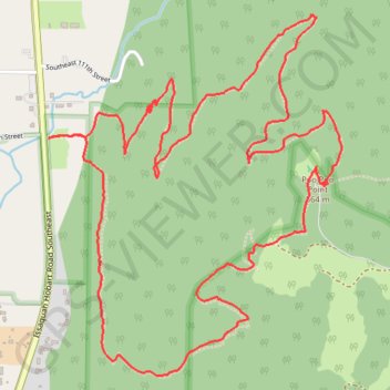
Poo Poo Point Rescue Trail
- Distance: 7.1 Km
- Elevation gain: 567 m
- Maximum elevation: 556 m
- Elevation loss: 567 m
- Minimum elevation: 54 m
- Moving time: 2 h 7 m
- Moving speed: 3.3 Km/h
- Maximum speed: 9.5 Km/h
- Total time: 2 h 14 m
- Global speed: 3.1 Km/h
- Date: 2024-04-28
Interactive map
GPS track profile
About this GPS track
Name: Poo Poo Point Rescue Trail GPS track, route, trail
Start: Chirico Trail, King County, Washington, 98027, United States (47.50056 -122.02198)
Coordinates: 47.49223 -122.02206 47.50487 -122.00685
Other GPS tracks
Click on a GPS track to view route, its statistics and profile.
Poo Poo Point - Rescue Loop
United States > Washington > King County
Distance: 7.8 Km • Elevation gain: 655 m • Maximum elevation: 555 m
Northern part of the Pacific Crest Trail (PCT)
United States > Oregon > Klamath County
Hike on the Pacific Crest National Scenic Trail from Crater Lake to Canada Border through Oregon and Washington along the Sierra Nevada and Cascade mountain ranges. #Hike #Mountain #SierraNevada #Cascade #Nature #Forest #Park #PCT
Distance: 1,198.3 Km • Elevation gain: 44,308 m • Maximum elevation: 2,307 m