Import a GPX file

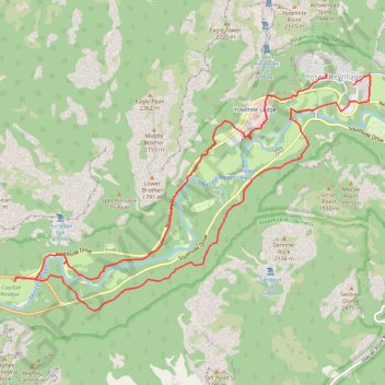
Yosemite Valley Loop

Loop hike from Yosemite Village via the Valley Loop Trail along Merced River in the Yosemite National Park. #Hike #Loop #Nature #River #Forest #Yosemite #Park

  • Distance: 14.9 Km
  • Elevation gain: 213 m
  • Maximum elevation: 1,240 m
  • Elevation loss: 214 m
  • Minimum elevation: 1,201 m
  • Moving time: 3 h 24 m
  • Moving speed: 4.4 Km/h
  • Maximum speed: 8.4 Km/h
  • Total time: 4 h 13 m
  • Global speed: 3.5 Km/h
  • Date: 2019-09-18

Interactive map

GPS track profile

About this GPS track

Other GPS tracks

Click on a GPS track to view route, its statistics and profile.

Upper Yosemite Falls

United States > California > Mariposa County > Yosemite Village > Yosemite Lodge

Yosemite National Park. Yosemite Creek. #Hike #Waterfall #River #Mountain #Forest #Nature #Yosemite

Distance: 10.2 Km • Elevation gain: 1,487 m • Maximum elevation: 2,039 m

Upper Yosemite Fall, Yosemite Point, Oh My Gosh Point and Columbia Rock

United States > California > Mariposa County > Yosemite Village > Yosemite Lodge

Hike from Yosemite Lodge via Upper Yosemite Fall Trail, Columbia Rock, Oh My Gosh Point and Yosemite Point in the Yosemite National Park. #Hike #Mountain #Falls #Overlook #Nature #Forest #Rock #Yosemite #Park

Distance: 14.9 Km • Elevation gain: 2,437 m • Maximum elevation: 2,143 m

Lower Yosemite Falls Loop

United States > California > Mariposa County > Yosemite Village > Yosemite Lodge

Yosemite National Park. Yosemite Creek. #Hike #Loop #Waterfall #River #Mountain #Forest #Nature #Yosemite

Distance: 1.9 Km • Elevation gain: 50 m • Maximum elevation: 1,249 m

Sentinel Dome, Glacier Point, Union Point and Taft Point Loop (Yosemite)

United States > California > Mariposa County

Loop hike from Sentinel Dome Trailhead to Sentinel Dome, Glacier Point, Union Point and Taft Point via Sentinel Dome Trail, Sentinel Dome, Glacier Point, Four Mile Trail, Union Point and Taft Point in the Yosemite National Park. #Hike #Loop #Mountain #Nature #Forest #Yosemite #Park

Distance: 21.5 Km • Elevation gain: 1,776 m • Maximum elevation: 2,478 m

Four Mile Trail, Yosemite (Californie)

États-Unis d'Amérique > Californie > Mariposa County > Curry Village

Randonnée pédestre. En aller-retour. #Randonnée

Distance: 16.4 Km • Elevation gain: 1,704 m • Maximum elevation: 2,197 m

Glacier Point

United States > California > Mariposa County > Curry Village

Hike to Glacier Point via Four Mile Trail in the Yoseite National Park. #Hike #Mountain #Forest #Nature #Yosemite #Park

Distance: 7.7 Km • Elevation gain: 1,250 m • Maximum elevation: 2,197 m

Taft Point - Sentinel Dome - Glacier Point

United States > California > Mariposa County

#Hike #Loop #Yosemite

Distance: 12.7 Km • Elevation gain: 832 m • Maximum elevation: 2,477 m

Upper Yosemite Fall

United States > California > Mariposa County > Yosemite Village > Yosemite Lodge

Hike to Upper Yosemite Fall via Columbia Rock in Yosemite National Park. #Hike #Fall #Nature #River #Forest #Park #Yosemite #Mountain

Distance: 5.6 Km • Elevation gain: 1,218 m • Maximum elevation: 2,047 m

Columbia Rock

United States > California > Mariposa County > Yosemite Village > Yosemite Lodge

Hike to the Columbia Rock by the Upper Yosemite Fall Trail in the Yosemite National Park. #Hike #Rock #Mountain #Forest #Nature #Yosemite #Park

Distance: 1.6 Km • Elevation gain: 357 m • Maximum elevation: 1,531 m

Yosemite North Dome Loop

United States > California > Mariposa County > Curry Village

Loop hike to North Dome via Lower Mirror Lake, Tenaya Creek, Valley Loop Trail, Snow Creek Trail, North Dome Trail, Upper Yosemite Fall Trail, Oh My Gosh Point and Columbia Rock in the Yosemite National Park. #Hike #Loop #Mountain #Nature #Lake #Forest #Fall #Park #Yosemite

Distance: 32.0 Km • Elevation gain: 2,275 m • Maximum elevation: 2,484 m

Sentinel Dome

United States > California > Mariposa County

Hike to Sentinel Dome in the Yosemite National Park. #Hike #Mountain #Nature #Forest #Yosemite #Park

Distance: 1.8 Km • Elevation gain: 133 m • Maximum elevation: 2,479 m

Glacier Point and Union Point via Four Mile Trail

United States > California > Mariposa County > Yosemite Village > Yosemite Lodge

Yosemite National Park. #Hike #Mountain #Forest #Nature #Yosemite

Distance: 15.2 Km • Elevation gain: 1,647 m • Maximum elevation: 2,197 m

Walker - Auberry

États-Unis d'Amérique > Californie > Mono County > Walker

Vélo. En aller simple entre Walker et Auberry. #Vélo

Distance: 354.0 Km • Elevation gain: 6,633 m • Maximum elevation: 3,039 m