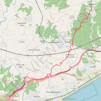
GR92 Vendrell
Randonnée entre Bonastre et Tarragona. #Randonnée
- Distance: 17.1 Km
- Elevation gain: 248 m
- Maximum elevation: 205 m
- Elevation loss: 404 m
- Minimum elevation: 14 m
- Moving time: 4 h 17 m
- Moving speed: 4.0 Km/h
- Maximum speed: 13.3 Km/h
- Total time: 4 h 47 m
- Global speed: 3.6 Km/h
- Date: 2010-02-24
Interactive map
GPS track profile
About this GPS track
Name: GR92 Vendrell GPS track, route, trail
Start: Passeig de Ponent, Bonastre, Bas-Pénédais, Tarragone, Catalogne, 43884, Espagne (41.22147 1.43973)
Coordinates: 41.14158 1.34581 41.22147 1.43977
Other GPS tracks
Click on a GPS track to view route, its statistics and profile.
Southern section — European Divide Trail
France > Auvergne-Rhône-Alpes > Drôme > Valence
Distance: 2,423.8 Km • Elevation gain: 42,375 m • Maximum elevation: 2,005 m
1 LUCENA - MONTPELLIER
Distance: 2,964.4 Km • Elevation gain: 29,500 m • Maximum elevation: 1,048 m
1 LUCENA - MONTPELLIER
Espagne > Andalousie > Lucena
Distance: 2,964.4 Km • Elevation gain: 29,500 m • Maximum elevation: 1,048 m
Stage 26: Valence to Saint-Jean-de-Fos — European Divide Trail
France > Auvergne-Rhône-Alpes > Drôme > Valence
Distance: 2,423.8 Km • Elevation gain: 42,375 m • Maximum elevation: 2,005 m
Stage 26: Valence to Saint-Jean-de-Fos — European Divide Trail
France > Auvergne-Rhône-Alpes > Drôme > Valence
Distance: 1,629.8 Km • Elevation gain: 30,841 m • Maximum elevation: 2,005 m
Monday Afternoon Flight
Espagne > Îles Baléares > Palma > Son Banya
Distance: 629.8 Km • Elevation gain: 26,635 m • Maximum elevation: 2,584 m
Santa Susana, Cardedeu, Castellbell i Vilar, Prades, Torto
Espagne > Catalogne > Maresme > Santa Susanna
Distance: 406.2 Km • Elevation gain: 12,199 m • Maximum elevation: 1,149 m