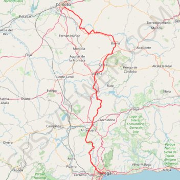
Málaga - Córdoba
One-way between Málaga and Córdoba.
- Distance: 226.5 Km
- Elevation gain: 4,872 m
- Maximum elevation: 979 m
- Elevation loss: 4,790 m
- Minimum elevation: 10 m
Interactive map
GPS track profile
About this GPS track
Name: Málaga - Córdoba GPS track, route, trail
Coordinates: 36.72071 -4.77069 37.86813 -4.32230
Other GPS tracks
Click on a GPS track to view route, its statistics and profile.
EuroVelo 1 (Spain)
Espagne > Andalousie > Côte occidentale > Ayamonte
Distance: 1,355.6 Km • Elevation gain: 14,587 m • Maximum elevation: 1,320 m
Southern section — European Divide Trail
France > Auvergne-Rhône-Alpes > Drôme > Valence
Distance: 2,423.8 Km • Elevation gain: 42,375 m • Maximum elevation: 2,005 m
Eurovelo 01 Spain + Portugal
France > Nouvelle-Aquitaine > Pyrénées-Atlantiques > Hendaye
Distance: 3,107.2 Km • Elevation gain: 30,592 m • Maximum elevation: 1,503 m
1 LUCENA - MONTPELLIER
Distance: 2,964.4 Km • Elevation gain: 29,500 m • Maximum elevation: 1,048 m
1 LUCENA - MONTPELLIER
Espagne > Andalousie > Lucena
Distance: 2,964.4 Km • Elevation gain: 29,500 m • Maximum elevation: 1,048 m
Southern Section — European Divide Trail
Espagne > Andalousie > Cazorla
Distance: 830.4 Km • Elevation gain: 19,253 m • Maximum elevation: 2,134 m
Stage 26: Valence to Saint-Jean-de-Fos — European Divide Trail
France > Auvergne-Rhône-Alpes > Drôme > Valence
Distance: 2,423.8 Km • Elevation gain: 42,375 m • Maximum elevation: 2,005 m
EuroVelo 1 (Spain)
Espagne > Andalousie > Côte occidentale > Ayamonte > Pozo del Camino > Fotea
Distance: 1,349.7 Km • Elevation gain: 13,641 m • Maximum elevation: 1,320 m
Stage 26: Valence to Saint-Jean-de-Fos — European Divide Trail
Distance: 859.0 Km • Elevation gain: 16,438 m • Maximum elevation: 1,490 m
Vila do Bispo -> Distrito 4 (495,2 km)
Distance: 1,306.4 Km • Elevation gain: 23,128 m • Maximum elevation: 2,134 m