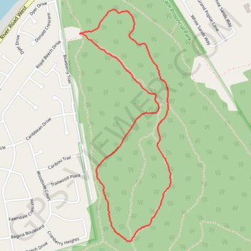
Wasaga Beach Provincial Park
#Hike #Snowshoes #Loop #WasagaBeach
- Distance: 4.0 Km
- Elevation gain: 19 m
- Maximum elevation: 197 m
- Elevation loss: 19 m
- Minimum elevation: 183 m
Interactive map
GPS track profile
About this GPS track
Name: Wasaga Beach Provincial Park GPS track, route, trail
Coordinates: 44.50383 -80.01571 44.51713 -80.00844
Topography: Simcoe County topographic map
Other GPS tracks
Click on a GPS track to view route, its statistics and profile.
Wasaga Beach - Orillia
Canada > Ontario > Simcoe County > Wasaga Beach
Distance: 81.4 Km • Elevation gain: 450 m • Maximum elevation: 343 m