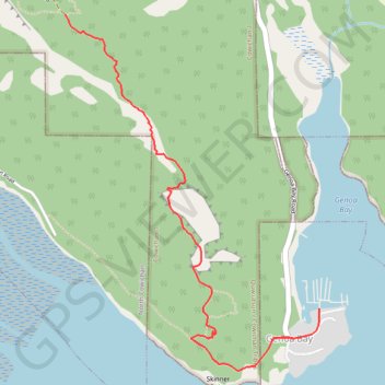
Genoa Bay - Mad Dog Trail
Mount Tzouhalem Ecological Reserve. Vancouver Island. #Hike #MountTzouhalem #Vancouver
- Distance: 6.4 Km
- Elevation gain: 521 m
- Maximum elevation: 486 m
- Elevation loss: 521 m
- Minimum elevation: 1 m
Interactive map
GPS track profile
About this GPS track
Name: Genoa Bay - Mad Dog Trail GPS track, route, trail
Coordinates: 48.75644 -123.61515 48.77165 -123.59871
Topography: Cowichan Valley Regional District topographic map
Other GPS tracks
Click on a GPS track to view route, its statistics and profile.