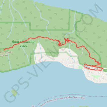
Bald Mountain - Cowichan Lake
#Hike
- Distance: 10.0 Km
- Elevation gain: 491 m
- Maximum elevation: 613 m
- Elevation loss: 494 m
- Minimum elevation: 176 m
Interactive map
GPS track profile
About this GPS track
Name: Bald Mountain - Cowichan Lake GPS track, route, trail
Coordinates: 48.83504 -124.16512 48.84305 -124.12952
Topography: Area I (Youbou / Meade Creek) topographic map