Kalk Bay Peak - Ridge Peak - St. James Peak - Muizenberg Peak
Interactive map
GPS track profile
About this GPS track
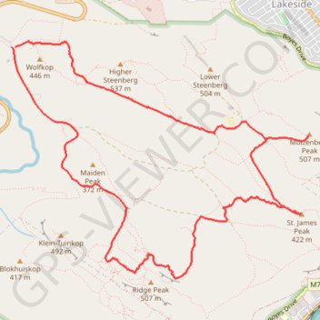
Name: Kalk Bay Peak - Ridge Peak - St. James Peak - Muizenberg Peak GPS track, route, trail
Start: A, Cape Town Ward 71, City of Cape Town, Western Cape, 7978, South Africa (-34.09163 18.42309)
End: A, Cape Town Ward 71, City of Cape Town, Western Cape, 7978, South Africa (-34.09163 18.42346)
Coordinates: -34.11483 18.42309 -34.09103 18.45898
Other GPS tracks
Click on a GPS track to view route, its statistics and profile.
Simon's Town - Cape Town
South Africa > Western Cape > City of Cape Town > Simon's Town
#Bike
Distance: 53.9 Km • Elevation gain: 1,127 m • Maximum elevation: 184 m