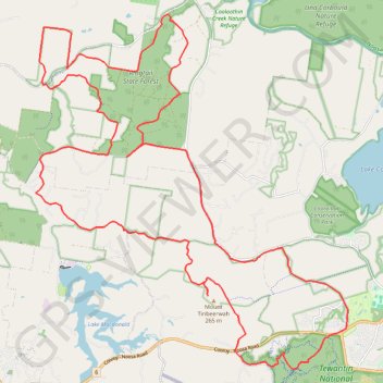
Tinbeerwah - Tewantin National Park - Ringtail State Forest
#MTB #Loop #Tinbeerwah #Tewantin #Ringtail
- Distance: 48.7 Km
- Elevation gain: 707 m
- Maximum elevation: 219 m
- Elevation loss: 707 m
- Minimum elevation: 6 m
Interactive map
GPS track profile
About this GPS track
Name: Tinbeerwah - Tewantin National Park - Ringtail State Forest GPS track, route, trail
Start: Wooroi Track, Tewantin, Noosa Shire, Queensland, 4565, Australia (-26.39944 153.01024)
End: Wooroi Track, Tewantin, Noosa Shire, Queensland, 4565, Australia (-26.39944 153.01027)
Coordinates: -26.40851 152.92213 -26.31353 153.01550
Other GPS tracks
Click on a GPS track to view route, its statistics and profile.