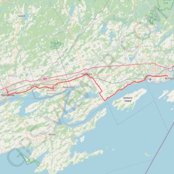
Belleville - Kingston
#Bike
- Distance: 92.7 Km
- Elevation gain: 394 m
- Maximum elevation: 115 m
- Elevation loss: 387 m
- Minimum elevation: 75 m
Interactive map
GPS track profile
About this GPS track
Name: Belleville - Kingston GPS track, route, trail
Coordinates: 44.14085 -77.39291 44.24852 -76.50413
Topography: Belleville topographic map
Other GPS tracks
Click on a GPS track to view route, its statistics and profile.
Cobourg - Belleville
Canada > Ontario > Northumberland County > Cobourg
#Bike
Distance: 81.5 Km • Elevation gain: 286 m • Maximum elevation: 118 m