Edith Lake Loop
Interactive map
GPS track profile
About this GPS track
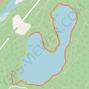
Name: Edith Lake Loop GPS track, route, trail
Coordinates: 52.90694 -118.04850 52.91911 -118.03250
Topography: Division No. 15 topographic map
Name: Edith Lake Loop GPS track, route, trail
Coordinates: 52.90694 -118.04850 52.91911 -118.03250
Topography: Division No. 15 topographic map