GPS tracks, routes, trails, hikes

GPS tracks visualization and sharing, free and without registration.

Import a GPX file

Cumberland - Allen Lake - Trent River

Vancouver Island. #Hike #MTB #Loop #Vancouver

  • Distance: 24.8 Km
  • Elevation gain: 691 m
  • Maximum elevation: 527 m
  • Elevation loss: 691 m
  • Minimum elevation: 136 m

Interactive map

GPS track profile

About this GPS track

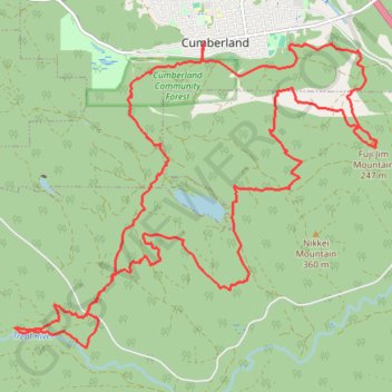
Name: Cumberland - Allen Lake - Trent River GPS track, route, trail.
Start: Welcome to the Cumberland Community Forest, Sutton Road, Cumberland, Comox Valley Regional District, British Columbia, V0R 1S0, Canada (49.61833 -125.03409)
End: Welcome to the Cumberland Community Forest, Sutton Road, Cumberland, Comox Valley Regional District, British Columbia, V0R 1S0, Canada (49.61833 -125.03408)
Coordinates: 49.58058 -125.07035 49.61833 -125.00104

Other GPS tracks

Deep Bay - Port Alberni - Cumberland

Canada > British Columbia > Comox Valley Regional District > Area A (Baynes Sound)

Vancouver Island. #Bike #Loop #Vancouver

Distance: 149.7 Km - Elevation gain: 3,296 m - Maximum elevation: 465 m - Coordinates: 49.25679 -125.21301 49.66057 -124.73345

Start: South Island Highway, Area A (Baynes Sound), Comox Valley Regional District, British Columbia, Canada (49.44737 -124.75662)

End: 3284, Third Street, Cumberland, Comox Valley Regional District, British Columbia, V0R 1S0, Canada (49.62014 -125.02801)

The Cumby Race Course

Canada > British Columbia > Comox Valley Regional District > Cumberland

#Run #Loop #Cumby

Distance: 20.7 Km - Elevation gain: 640 m - Maximum elevation: 422 m - Coordinates: 49.58784 -125.04874 49.61802 -124.99883

Start: South Wellington Colliery Railway Trail, Cumberland, Comox Valley Regional District, British Columbia, V0R 1S0, Canada (49.61725 -125.02923)

End: 2667, Derwent Avenue, Cumberland, Comox Valley Regional District, British Columbia, V0R 1S0, Canada (49.61746 -125.03250)

Fanny Bay - Campbell River

Canada > British Columbia > Comox Valley Regional District > Area A (Baynes Sound)

Vancouver Island. #Bike #Fanny #Campbell #Vancouver

Distance: 79.1 Km - Elevation gain: 481 m - Maximum elevation: 93 m - Coordinates: 49.47236 -125.29609 50.03768 -124.79525

Start: 8256, South Island Highway, Area A (Baynes Sound), Comox Valley Regional District, British Columbia, Canada (49.47236 -124.79525)

End: Campbell River Road, Campbell River, Strathcona Regional District, British Columbia, V9W 4Z3, Canada (50.03711 -125.29609)