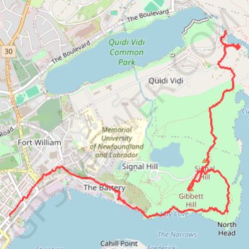
St. Johns - Signal Hill - Quidi Vidi
Signal Hill National Historic Site. #Hike #SignalHill #Atlantic
- Distance: 5.9 Km
- Elevation gain: 284 m
- Maximum elevation: 149 m
- Elevation loss: 298 m
- Minimum elevation: 0 m
Interactive map
GPS track profile
About this GPS track
Name: St. Johns - Signal Hill - Quidi Vidi GPS track, route, trail
Coordinates: 47.56747 -52.70410 47.58277 -52.67611
Topography: St. John's topographic map
Other GPS tracks
Click on a GPS track to view route, its statistics and profile.
Whitbourne - St. John's
Canada > Newfoundland and Labrador > Whitbourne
#Bike #Whitbourne #StJohns #Newfoundland #Atlantic
Distance: 103.3 Km • Elevation gain: 1,230 m • Maximum elevation: 234 m
East Coast Trail - Sugarloaf Path
Canada > Newfoundland and Labrador > Logy Bay-Middle Cove-Outer Cove
Distance: 8.4 Km • Elevation gain: 447 m • Maximum elevation: 154 m