GPS tracks, routes, trails, hikes

GPS tracks visualization and sharing, free and without registration.

Import a GPX file

Irricana - Drumheller

#Bike #Irricana #Drumheller

  • Distance: 75.0 Km
  • Elevation gain: 324 m
  • Maximum elevation: 961 m
  • Elevation loss: 571 m
  • Minimum elevation: 682 m

Interactive map

GPS track profile

About this GPS track

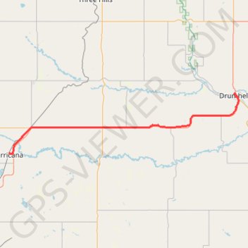
Name: Irricana - Drumheller GPS track, route, trail.
Start: Founder's Park Playground, 1st Street, Irricana, Town of Irricana, Alberta, T0M 1B0, Canada (51.32325 -113.60644)
End: Willow Avenue, North Drumheller, Drumheller, Alberta, T0J 0Y0, Canada (51.46854 -112.71473)
Coordinates: 51.32129 -113.60644 51.47001 -112.70057

Other GPS tracks

Cochrane - Irricana

Canada > Alberta > Town of Cochrane > Cochrane

#Bike #Cochrane #Irricana

Distance: 79.0 Km - Elevation gain: 576 m - Maximum elevation: 1,304 m - Coordinates: 51.17536 -114.48690 51.32366 -113.60644

Start: Bow Rivers Edge Campground, Riviera View, Riversong, Cochrane, Town of Cochrane, Alberta, T4C 0Y1, Canada (51.17536 -114.45591)

End: Founder's Park Playground, 1st Street, Irricana, Town of Irricana, Alberta, T0M 1B0, Canada (51.32325 -113.60644)