Kenora - Sioux Narrows
Interactive map
GPS track profile
About this GPS track
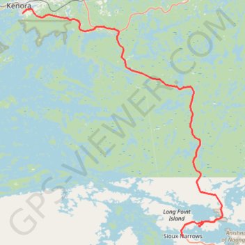
Name: Kenora - Sioux Narrows GPS track, route, trail
Coordinates: 49.40758 -94.47956 49.76014 -94.00010
Topography: Kenora topographic map
Other GPS tracks
Click on a GPS track to view route, its statistics and profile.
Départ - Alberta
Canada > Colombie-Britannique > District régional du Grand Vancouver > Vancouver
Distance: 2,596.8 Km • Elevation gain: 17,360 m • Maximum elevation: 2,042 m
Whiteshell - Kenora
Canada > Manitoba > Division No. 1 > Unorganized Division No. 1
#Bike #Whiteshell #Kenora
Distance: 69.2 Km • Elevation gain: 577 m • Maximum elevation: 382 m
Kenora - Vermilion Bay
Canada > Ontario > Kenora District > Kenora
Distance: 87.1 Km • Elevation gain: 894 m • Maximum elevation: 452 m