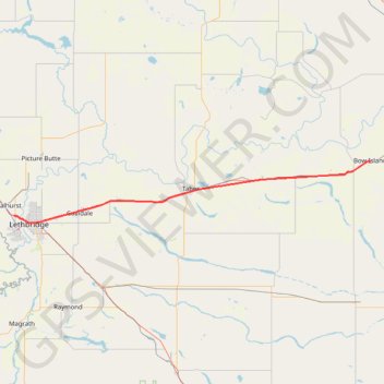
Lethbridge - Bow Island
- Distance: 116.9 Km
- Elevation gain: 273 m
- Maximum elevation: 924 m
- Elevation loss: 301 m
- Minimum elevation: 792 m
Interactive map
GPS track profile
About this GPS track
Name: Lethbridge - Bow Island GPS track, route, trail
Start: Lethbridge KOA, Bridge Drive W, Lethbridge, Alberta, T1J 4B4, Canada (49.71125 -112.87302)
End: Centre Street, Bow Island, Division No. 1, Alberta, T0K 0G0, Canada (49.86221 -111.37945)
Coordinates: 49.69609 -112.89368 49.86738 -111.37941
Topography: Lethbridge topographic map
Other GPS tracks
Click on a GPS track to view route, its statistics and profile.
Départ - Alberta
Canada > Colombie-Britannique > District régional du Grand Vancouver > Vancouver
Distance: 2,596.8 Km • Elevation gain: 17,360 m • Maximum elevation: 2,042 m
Bow Island - Medicine Hat
Canada > Alberta > Division No. 1 > Bow Island
Distance: 59.4 Km • Elevation gain: 162 m • Maximum elevation: 834 m
Pincher Creek - Lethbridge
Canada > Alberta > Division No. 3 > Pincher Creek
#Bike #PincherCreek #Lethbridge
Distance: 101.5 Km • Elevation gain: 228 m • Maximum elevation: 1,146 m