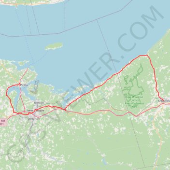
Pictou - Antigonish
Gulf of Saint Lawrence. #Bike #Pictou #Antigonish #SaintLawrence #Atlantic
- Distance: 101.8 Km
- Elevation gain: 808 m
- Maximum elevation: 147 m
- Elevation loss: 820 m
- Minimum elevation: -1 m
Interactive map
GPS track profile
About this GPS track
Name: Pictou - Antigonish GPS track, route, trail
Coordinates: 45.57092 -62.79803 45.78394 -61.99498
Topography: Town of Pictou topographic map
Other GPS tracks
Click on a GPS track to view route, its statistics and profile.
Antigonish - Whycocomagh
Canada > Nova Scotia > Town of Antigonish > Antigonish
Gulf of Saint Lawrence. Cape Breton Island. #Bike #Antigonish #Whycocomagh #SaintLawrence #CapeBreton
Distance: 104.0 Km • Elevation gain: 891 m • Maximum elevation: 135 m
Pictou - Brookfield
Canada > Nova Scotia > Town of Pictou > Pictou
#Bike #Pictou #Brookfield
Distance: 71.5 Km • Elevation gain: 535 m • Maximum elevation: 208 m
Pictou - Antigonish
Canada > Nova Scotia > Town of Pictou > Pictou
#Bike #Pictou #Antigonish
Distance: 74.3 Km • Elevation gain: 744 m • Maximum elevation: 154 m