White River - Wawa
#Bike #WhiteRiver #Wawa
- Distance: 92.2 Km
- Elevation gain: 560 m
- Maximum elevation: 471 m
- Elevation loss: 645 m
- Minimum elevation: 253 m
Interactive map
GPS track profile
About this GPS track
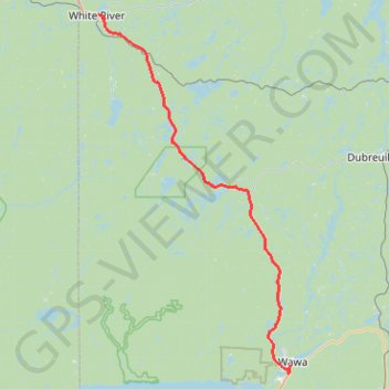
Name: White River - Wawa GPS track, route, trail
Coordinates: 47.97074 -85.27875 48.59450 -84.78024
Topography: Algoma District topographic map
Other GPS tracks
Click on a GPS track to view route, its statistics and profile.
Wawa - Lake Superior Provincial Park
Canada > Ontario > Algoma District > Wawa
#Bike #Wawa #LakeSuperior
Distance: 89.4 Km • Elevation gain: 890 m • Maximum elevation: 408 m