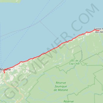
Matane - Sainte-Anne-des-Monts
Saint Lawrence River. #Bike #Matane #SainteAnneDesMonts #SaintLawrence
- Distance: 88.8 Km
- Elevation gain: 788 m
- Maximum elevation: 90 m
- Elevation loss: 802 m
- Minimum elevation: 0 m
Interactive map
GPS track profile
About this GPS track
Name: Matane - Sainte-Anne-des-Monts GPS track, route, trail
Coordinates: 48.82088 -67.54630 49.12713 -66.51072
Topography: Matane topographic map
Other GPS tracks
Click on a GPS track to view route, its statistics and profile.
La Traversée des Chic-Chocs
Canada > Québec > La Matanie > Rivière-Bonjour
Randonnée entre Les Méchins et Cap-au-Renard. #Randonnée
Distance: 96.1 Km • Elevation gain: 4,727 m • Maximum elevation: 1,135 m
Rimouski - Matane
Canada > Quebec > Rimouski-Neigette > Rimouski > L'Anse-au-Sable
Saint Lawrence River. #Bike #Rimouski #Matane #SaintLawrence
Distance: 104.5 Km • Elevation gain: 485 m • Maximum elevation: 58 m
Sainte-Anne-des-Monts - Madeleine
Canada > Quebec > La Haute-Gaspésie > Sainte-Anne-des-Monts
Saint Lawrence River. #Bike #SainteAnneDesMonts #Madeleine #SaintLawrence
Distance: 92.5 Km • Elevation gain: 866 m • Maximum elevation: 107 m