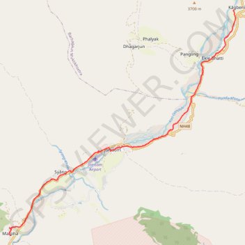
Tour Annapurna - Jour 12 - Kagbeni - Marpha
Randonnée entre Kagbeni et Jomsom. #Randonnée
- Distance: 17.2 Km
- Elevation gain: 358 m
- Maximum elevation: 2,860 m
- Elevation loss: 503 m
- Minimum elevation: 2,682 m
- Moving time: 3 h 47 m
- Moving speed: 4.5 Km/h
- Maximum speed: 28.2 Km/h
- Total time: 7 h 18 m
- Global speed: 2.4 Km/h
- Date: 2014-04-10
Interactive map
GPS track profile
About this GPS track
Name: Tour Annapurna - Jour 12 - Kagbeni - Marpha GPS track, route, trail
End: जेरी गल्ली, Marpha, Gharapjhong-02, Gharapjhong, मुस्ताङ, Gandaki, Népal (28.75378 83.68670)
Coordinates: 28.75099 83.68582 28.83685 83.78391
Other GPS tracks
Click on a GPS track to view route, its statistics and profile.
Annapurna - Example
Népal > Gandaki > मनाङ > Dharapani
Distance: 167.6 Km • Elevation gain: 12,204 m • Maximum elevation: 6,020 m