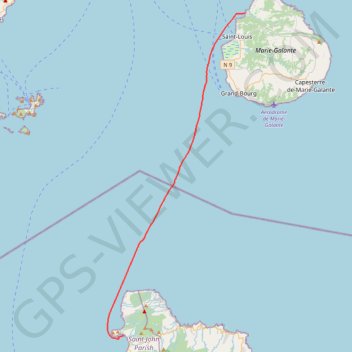
Portsmooth-Anse Canot
- Distance: 52.5 Km
- Elevation gain: 0 m
- Maximum elevation: 0 m
- Elevation loss: 0 m
- Minimum elevation: 0 m
- Moving time: 4 h 20 m
- Moving speed: 12.1 Km/h
- Maximum speed: 17.3 Km/h
- Total time: 4 h 24 m
- Global speed: 11.9 Km/h
- Date: 2023-10-27
Interactive map
GPS track profile
About this GPS track
Name: Portsmooth-Anse Canot GPS track, route, trail
Start: Bay Street, Cotton Hill, Portsmouth, Saint John Parish, Dominique (15.58226 -61.46323)
Coordinates: 15.57838 -61.48405 15.98248 -61.30663
Other GPS tracks
Click on a GPS track to view route, its statistics and profile.
Vieux Fort
France > Guadeloupe > Saint-Louis > Moustique
Distance: 9.1 Km • Elevation gain: 181 m • Maximum elevation: 138 m
Les Sources
France > Guadeloupe > Grand-Bourg > Siblet
Distance: 6.4 Km • Elevation gain: 141 m • Maximum elevation: 97 m