Rome, Tivoli, Villa Hadriana et Villa d'Este
Randonnée pédestre. Depuis Tivoli. #Randonnée
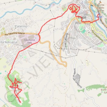
- Distance: 10.7 Km
- Elevation gain: 378 m
- Maximum elevation: 255 m
- Elevation loss: 210 m
- Minimum elevation: 64 m
- Moving time: 3 h 1 m
- Moving speed: 3.5 Km/h
- Maximum speed: 6.0 Km/h
- Total time: 7 h 6 m
- Global speed: 1.5 Km/h
- Date: 2013-02-27
Interactive map
GPS track profile
About this GPS track
Name: Rome, Tivoli, Villa Hadriana et Villa d'Este GPS track, route, trail
End: Tivoli, Viale Giuseppe Mazzini, Tivoli, Roma Capitale, Latium, 00019, Italie (41.96165 12.80508)
Coordinates: 41.93790 12.77200 41.96453 12.80508
Other GPS tracks
Click on a GPS track to view route, its statistics and profile.
Percorso selezionato
Italie > Lombardie > Côme > Côme
Percorso calcolato con http://www.bicitalia.org/it/routing-gpx
Distance: 1,543.9 Km • Elevation gain: 17,951 m • Maximum elevation: 1,034 m