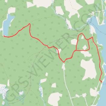
Lake Tormont Trails
- Distance: 10.3 Km
- Elevation gain: 96 m
- Maximum elevation: 225 m
- Elevation loss: 95 m
- Minimum elevation: 176 m
Interactive map
GPS track profile
About this GPS track
Name: Lake Tormont Trails GPS track, route, trail
Coordinates: 44.73395 -64.78180 44.75040 -64.74289
Topography: Municipality of the County of Kings topographic map
Other GPS tracks
Click on a GPS track to view route, its statistics and profile.
Lake Tormont Hiking
Canada > Nova Scotia > Municipality of the County of Kings > East Dalhousie
Distance: 15.9 Km • Elevation gain: 156 m • Maximum elevation: 226 m