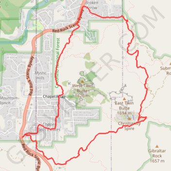
Chicken Point Loop
Loop hike from Sedona to Chicken Point via Bell Rock Pathway, Little Horse Trail and Broken Arrow Trail in the Coconino National Forest. #Hike #Loop #Nature #Overlook #Rock #Forest
- Distance: 10.4 Km
- Elevation gain: 222 m
- Maximum elevation: 1,410 m
- Elevation loss: 222 m
- Minimum elevation: 1,287 m
- Moving time: 2 h 37 m
- Moving speed: 4.0 Km/h
- Maximum speed: 6.0 Km/h
- Total time: 2 h 59 m
- Global speed: 3.5 Km/h
- Date: 2009-04-10
Interactive map
GPS track profile
About this GPS track
Name: Chicken Point Loop GPS track, route, trail
Coordinates: 34.82155 -111.77821 34.84782 -111.75291
Other GPS tracks
Click on a GPS track to view route, its statistics and profile.
Cathedral Rock Loop
United States > Arizona > Coconino County
Loop hike to Cathedral Rock Viewpoint via Slim Shady Trail, Templeton Trail, Cathedral Rock Trail, Oak Creek, Baldwin Trail, Hiline Trail and Yavapai Vista in the Coconino National Forest. #Hike #Loop #Rock #Nature #Forest #River #Mountain
Distance: 14.4 Km • Elevation gain: 684 m • Maximum elevation: 1,472 m