Secret path
- Distance: 9.3 Km
- Elevation gain: 181 m
- Maximum elevation: 455 m
- Elevation loss: 588 m
- Minimum elevation: 47 m
Interactive map
GPS track profile
About this GPS track
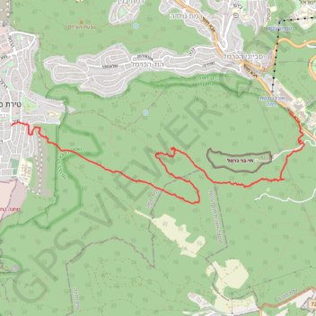
Name: Secret path GPS track, route, trail
Coordinates: 32.74742 34.97298 32.76017 35.02185
Other GPS tracks
Click on a GPS track to view route, its statistics and profile.
Home78Rec
Israel > Haifa District > Nesher
Distance: 78.4 Km • Elevation gain: 1,479 m • Maximum elevation: 461 m