Vers les sommets de l'Etna
Randonnée pédestre. En aller simple. #Randonnée
- Distance: 7.0 Km
- Elevation gain: 161 m
- Maximum elevation: 2,923 m
- Elevation loss: 1,033 m
- Minimum elevation: 1,910 m
- Moving time: 2 h 12 s
- Moving speed: 3.5 Km/h
- Maximum speed: 6.7 Km/h
- Total time: 3 h 35 m
- Global speed: 2.0 Km/h
- Date: 2013-05-03
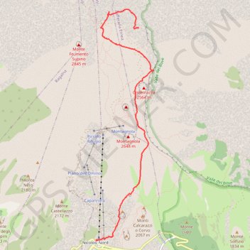
Interactive map
GPS track profile
About this GPS track
Name: Vers les sommets de l'Etna GPS track, route, trail
Start: Sentiero ai Crateri Barbagallo, Zafferana Etnea, Catane, Sicile, 95030, Italie (37.73550 15.00722)
Coordinates: 37.70048 14.99840 37.73863 15.01050
Other GPS tracks
Click on a GPS track to view route, its statistics and profile.
Randonnée sur l'Etna
Italie > Sicile > Catane > Zafferana Etnea
Distance: 11.0 Km • Elevation gain: 408 m • Maximum elevation: 3,283 m
2018-05-13 12:23:22
Italie > Sicile > Catane > Nicolosi > Nicolosi Nord
En boucle. #Boucle
Distance: 2.2 Km • Elevation gain: 120 m • Maximum elevation: 2,003 m