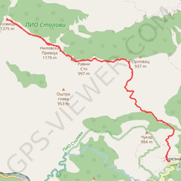
Planinarski dom Brezna - vrh Kamarišta (Usovica) 1375 mnv
- Distance: 22.0 Km
- Elevation gain: 989 m
- Maximum elevation: 1,371 m
- Elevation loss: 989 m
- Minimum elevation: 629 m
- Moving time: 5 h 10 m
- Moving speed: 4.2 Km/h
- Maximum speed: 17.1 Km/h
- Total time: 6 h 32 m
- Global speed: 3.4 Km/h
- Date: 2021-04-17
Interactive map
GPS track profile
About this GPS track
Name: Planinarski dom Brezna - vrh Kamarišta (Usovica) 1375 mnv GPS track, route, trail
Coordinates: 43.56561 20.61119 43.60918 20.68179
Other GPS tracks
Click on a GPS track to view route, its statistics and profile.
Tour d'Europe
France > Bretagne > Finistère > Concarneau > Landan Creis
Distance: 7,132.9 Km • Elevation gain: 44,603 m • Maximum elevation: 2,433 m
De Giromagny à Sofia
France > Bourgogne-Franche-Comté > Territoire-de-Belfort > Giromagny
Distance: 1,875.9 Km • Elevation gain: 12,108 m • Maximum elevation: 1,054 m
2022_Yu
Slovenia > Ajdovščina > Žapuže
Distance: 2,457.3 Km • Elevation gain: 32,048 m • Maximum elevation: 1,950 m