LaPal_51_Los Canarios - San Antonio - Teneguia - Faro
- Distance: 13.0 Km
- Elevation gain: 731 m
- Maximum elevation: 646 m
- Elevation loss: 731 m
- Minimum elevation: 13 m
Interactive map
GPS track profile
About this GPS track
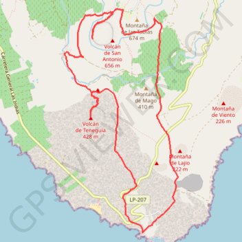
Name: LaPal_51_Los Canarios - San Antonio - Teneguia - Faro GPS track, route, trail
Coordinates: 28.45547 -17.85615 28.48729 -17.83771
Other GPS tracks
Click on a GPS track to view route, its statistics and profile.
Volcán Teneguía. La Palma
Espagne > Fuencaliente de la Palma > Los Canarios > La Fajana
Randonnée pédestre. Depuis Los Canarios. #Randonnée
Distance: 9.6 Km • Elevation gain: 102 m • Maximum elevation: 718 m