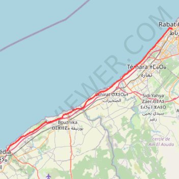
20210912 sortie 120km.gpx
- Distance: 120.5 Km
- Elevation gain: 631 m
- Maximum elevation: 36 m
- Elevation loss: 632 m
- Minimum elevation: 1 m
- Moving time: 5 h 23 m
- Moving speed: 22.3 Km/h
- Maximum speed: 37.2 Km/h
- Total time: 5 h 40 m
- Global speed: 21.3 Km/h
- Date: 2021-09-12
Interactive map
GPS track profile
About this GPS track
Name: 20210912 sortie 120km.gpx GPS track, route, trail
Coordinates: 33.71565 -7.34275 34.02265 -6.84593
Other GPS tracks
Click on a GPS track to view route, its statistics and profile.
Maroc en boucle depuis Tanger
Maroc > pachalik de Tanger > Tanger
Distance: 3,028.7 Km • Elevation gain: 27,253 m • Maximum elevation: 2,301 m
Marruecos Junio 2019. De Berguent a Esmara
Maroc > Pachalik de Ain Bni Mathar > Ain Bni Mathar
Distance: 2,271.6 Km • Elevation gain: 11,817 m • Maximum elevation: 1,454 m