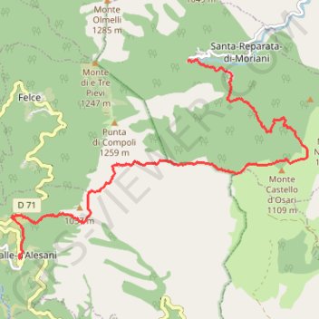
Penti - Valle d'alesani
En aller simple entre Santa-Reparata-di-Moriani et Valle-d'Alesani.
- Distance: 11.3 Km
- Elevation gain: 741 m
- Maximum elevation: 1,026 m
- Elevation loss: 762 m
- Minimum elevation: 579 m
- Moving time: 3 h 50 m
- Moving speed: 2.9 Km/h
- Maximum speed: 5.4 Km/h
- Total time: 5 h 23 m
- Global speed: 2.1 Km/h
- Date: 2015-06-22
Interactive map
GPS track profile
About this GPS track
Name: Penti - Valle d'alesani GPS track, route, trail
Coordinates: 42.32639 9.41389 42.35541 9.47237
Other GPS tracks
Click on a GPS track to view route, its statistics and profile.
1 LUCENA - MONTPELLIER
Distance: 2,964.4 Km • Elevation gain: 29,500 m • Maximum elevation: 1,048 m
1 LUCENA - MONTPELLIER
Espagne > Andalousie > Lucena
Distance: 2,964.4 Km • Elevation gain: 29,500 m • Maximum elevation: 1,048 m
Mare a Mare Nord
France > Corse > Haute-Corse > Valle-di-Campoloro
Distance: 135.9 Km • Elevation gain: 8,160 m • Maximum elevation: 1,593 m
Percorso selezionato
Italie > Lombardie > Côme > Côme
Percorso calcolato con http://www.bicitalia.org/it/routing-gpx
Distance: 1,543.9 Km • Elevation gain: 17,951 m • Maximum elevation: 1,034 m
Ajaccio - Bastia par le sud
France > Corse > Corse-du-Sud > Ajaccio
Vélo. En aller simple entre Ajaccio et Bastia. #Vélo
Distance: 337.2 Km • Elevation gain: 4,747 m • Maximum elevation: 556 m
TG6ak
France > Corse > Haute-Corse > Bastia
tour de corse vélo de voyage trace en préparation
Distance: 811.0 Km • Elevation gain: 22,311 m • Maximum elevation: 1,478 m
Valle d'Alesani - Pianellu
France > Corse > Haute-Corse > Valle-d'Alesani > Tofo
En aller simple entre Valle-d'Alesani et Pianello.
Distance: 13.5 Km • Elevation gain: 818 m • Maximum elevation: 1,109 m
Mare a Mare Nord : de Moriani à Penti
France > Corse > Haute-Corse > Padulella-Moriani-Plage
En aller simple entre San-Nicolao et Santa-Reparata-di-Moriani.
Distance: 10.7 Km • Elevation gain: 738 m • Maximum elevation: 608 m
E08 - Prunete - Bast
France > Corse > Haute-Corse > Cervione
Distance: 139.1 Km • Elevation gain: 3,617 m • Maximum elevation: 986 m
E06 - Aléria - Basti
France > Corse > Haute-Corse > Aléria > Listinco Pastoriccia
Distance: 150.7 Km • Elevation gain: 3,402 m • Maximum elevation: 986 m