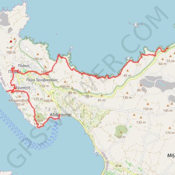
Klima Plaka et côte nord de Milos
Randonnée depuis Adamas. #Randonnée
- Distance: 19.0 Km
- Elevation gain: 554 m
- Maximum elevation: 225 m
- Elevation loss: 552 m
- Minimum elevation: 0 m
- Moving time: 5 h 10 m
- Moving speed: 3.7 Km/h
- Maximum speed: 7.3 Km/h
- Total time: 5 h 48 m
- Global speed: 3.3 Km/h
- Date: 2013-07-19
Interactive map
GPS track profile
About this GPS track
Name: Klima Plaka et côte nord de Milos GPS track, route, trail
Coordinates: 36.72066 24.41894 36.75427 24.50381