Itinerario1 track completo
- Distance: 13.1 Km
- Elevation gain: 352 m
- Maximum elevation: 1,286 m
- Elevation loss: 442 m
- Minimum elevation: 950 m
- Moving time:
- Moving speed: inf Km/h
- Maximum speed: 0.1 Km/h
- Total time: 1 h 48 m
- Global speed: 7.2 Km/h
- Date: 2013-11-03
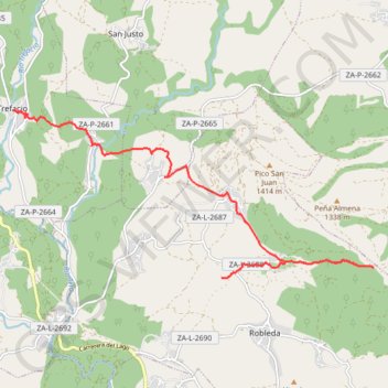
Interactive map
GPS track profile
About this GPS track
Name: Itinerario1 track completo GPS track, route, trail
End: Calle de Don Manuel, Trefacio, Zamora, Castille-et-León, 49350, Espagne (42.12115 -6.65090)
Coordinates: 42.09223 -6.65101 42.12115 -6.56790
Other GPS tracks
Click on a GPS track to view route, its statistics and profile.
Eurovelo 01 Spain + Portugal
France > Nouvelle-Aquitaine > Pyrénées-Atlantiques > Hendaye
Distance: 3,107.2 Km • Elevation gain: 30,592 m • Maximum elevation: 1,503 m
EuroVelo 1 (Spain)
Espagne > Andalousie > Côte occidentale > Ayamonte
Distance: 1,355.6 Km • Elevation gain: 14,587 m • Maximum elevation: 1,320 m
Southern section — European Divide Trail
France > Auvergne-Rhône-Alpes > Drôme > Valence
Distance: 2,423.8 Km • Elevation gain: 42,375 m • Maximum elevation: 2,005 m
Stage 26: Valence to Saint-Jean-de-Fos — European Divide Trail
France > Auvergne-Rhône-Alpes > Drôme > Valence
Distance: 2,423.8 Km • Elevation gain: 42,375 m • Maximum elevation: 2,005 m
EuroVelo 1 (Spain)
Espagne > Andalousie > Côte occidentale > Ayamonte > Pozo del Camino > Fotea
Distance: 1,349.7 Km • Elevation gain: 13,641 m • Maximum elevation: 1,320 m
De Villeneuve-sur-Lot à Guimarães
France > Nouvelle-Aquitaine > Lot-et-Garonne > Villeneuve-sur-Lot
Distance: 2,024.3 Km • Elevation gain: 22,121 m • Maximum elevation: 1,339 m
18/10/2020 12:05:36
Espagne > Pays basque autonome > Basse-Bidassoa > Fontarrabie
18/10/2020 12:05:36
Distance: 1,765.7 Km • Elevation gain: 32,710 m • Maximum elevation: 1,607 m