Rome, Ostia Antica et Lido di Ostia
Randonnée pédestre. En aller simple. #Randonnée
- Distance: 9.4 Km
- Elevation gain: 36 m
- Maximum elevation: 10 m
- Elevation loss: 33 m
- Minimum elevation: 0 m
- Moving time: 2 h 15 m
- Moving speed: 4.2 Km/h
- Maximum speed: 10.9 Km/h
- Total time: 2 h 42 m
- Global speed: 3.5 Km/h
- Date: 2013-02-28
Interactive map
GPS track profile
About this GPS track
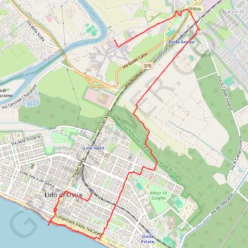
Name: Rome, Ostia Antica et Lido di Ostia GPS track, route, trail
Coordinates: 41.72600 12.27546 41.76030 12.30586
Other GPS tracks
Click on a GPS track to view route, its statistics and profile.
1 LUCENA - MONTPELLIER
Distance: 2,964.4 Km • Elevation gain: 29,500 m • Maximum elevation: 1,048 m
1 LUCENA - MONTPELLIER
Espagne > Andalousie > Lucena
Distance: 2,964.4 Km • Elevation gain: 29,500 m • Maximum elevation: 1,048 m
Percorso selezionato
Italie > Lombardie > Côme > Côme
Percorso calcolato con http://www.bicitalia.org/it/routing-gpx
Distance: 1,543.9 Km • Elevation gain: 17,951 m • Maximum elevation: 1,034 m