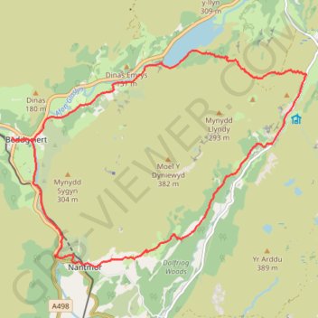
Beddgelert, Llyn Dinas, Blaen Nanmor and Nantmor circuit
- Distance: 15.2 Km
- Elevation gain: 393 m
- Maximum elevation: 182 m
- Elevation loss: 393 m
- Minimum elevation: 8 m
- Moving time: 4 h 43 m
- Moving speed: 3.2 Km/h
- Maximum speed: 5.9 Km/h
- Total time: 6 h 38 m
- Global speed: 2.3 Km/h
- Date: 2024-04-24
Interactive map
GPS track profile
About this GPS track
Name: Beddgelert, Llyn Dinas, Blaen Nanmor and Nantmor circuit GPS track, route, trail
Start: Dol Fair, Beddgelert, Gwynedd, Wales, LL55 4YJ, United Kingdom (53.01191 -4.10599)
End: Dol Fair, Beddgelert, Gwynedd, Wales, LL55 4YJ, United Kingdom (53.01186 -4.10602)
Coordinates: 52.99345 -4.10602 53.02424 -4.03660
Other GPS tracks
Click on a GPS track to view route, its statistics and profile.
TT22 J9 M7/06 : Heysham Port à Aberystwyth
Royaume-Uni > Angleterre > Lancashire > Lancaster > Morecambe
Distance: 347.4 Km • Elevation gain: 4,043 m • Maximum elevation: 419 m