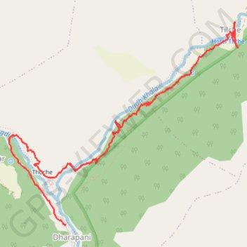
Dharapani Ascension
- Distance: 8.3 Km
- Elevation gain: 819 m
- Maximum elevation: 2,313 m
- Elevation loss: 451 m
- Minimum elevation: 1,902 m
- Moving time: 2 h 15 m
- Moving speed: 3.7 Km/h
- Maximum speed: 31.0 Km/h
- Total time: 2 h 16 m
- Global speed: 3.6 Km/h
- Date: 2021-10-02
Interactive map
GPS track profile
About this GPS track
Name: Dharapani Ascension GPS track, route, trail
Start: NH25, Nashong-04, Dharapani, Nashong, मनाङ, Gandaki, 33500, Népal (28.52058 84.35751)
End: Manaslu Circuit, Nashong-07, Tilche, Nashong, मनाङ, Gandaki, Népal (28.54605 84.38187)
Coordinates: 28.52046 84.34943 28.54616 84.38233
Other GPS tracks
Click on a GPS track to view route, its statistics and profile.
Annapurna - Example
Népal > Gandaki > मनाङ > Dharapani
Distance: 167.6 Km • Elevation gain: 12,204 m • Maximum elevation: 6,020 m