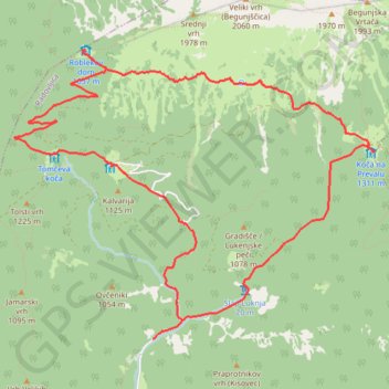
J4A_Roblek
This curcular route in the Karawanke mountain range will reward a hiker with pristine nature and beautiful views towards the Julian Alps.
- Distance: 11.5 Km
- Elevation gain: 1,074 m
- Maximum elevation: 1,637 m
- Elevation loss: 1,074 m
- Minimum elevation: 710 m
Interactive map
GPS track profile
About this GPS track
Name: J4A_Roblek GPS track, route, trail
Start: Radovljica, 4275, Slovénie (46.39605 14.21966)
End: Radovljica, 4275, Slovénie (46.39605 14.21966)
Coordinates: 46.39605 14.20450 46.41783 14.24380
Other GPS tracks
Click on a GPS track to view route, its statistics and profile.
Tour d'Europe
France > Bretagne > Finistère > Concarneau > Landan Creis
Distance: 7,132.9 Km • Elevation gain: 44,603 m • Maximum elevation: 2,433 m
Eurovelo 6
France > Pays de la Loire > Loire-Atlantique > Saint-Brevin-les-Pins
Distance: 4,530.3 Km • Elevation gain: 18,043 m • Maximum elevation: 856 m
De Giromagny à Sofia
France > Bourgogne-Franche-Comté > Territoire-de-Belfort > Giromagny
Distance: 1,875.9 Km • Elevation gain: 12,108 m • Maximum elevation: 1,054 m
Trace Les Balkans
Italie > Frioul-Vénétie julienne > Pordenone > Versutta
Distance: 2,720.6 Km • Elevation gain: 41,224 m • Maximum elevation: 1,799 m
Euro 6
France > Pays de la Loire > Loire-Atlantique > Saint-Brevin-les-Pins
Distance: 4,239.9 Km • Elevation gain: 15,869 m • Maximum elevation: 856 m
Trace
France > Normandie > Seine-Maritime > Saint-Laurent-de-Brèvedent
Distance: 2,147.5 Km • Elevation gain: 23,741 m • Maximum elevation: 1,618 m
J4B_Roblek
Standard approach from to to the legendary Roblek Mountain leads from Draga valley through the dense forests and alpine pastures of Mt. Begunjščica.
Distance: 11.2 Km • Elevation gain: 959 m • Maximum elevation: 1,633 m