Conduite160
Length: 3.08 km (1.914 mi)
- Distance: 3.1 Km
- Elevation gain: 14 m
- Maximum elevation: 1,494 m
- Elevation loss: 5 m
- Minimum elevation: 1,483 m
Interactive map
GPS track profile
About this GPS track
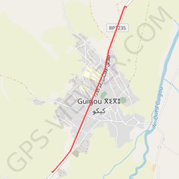
Name: Conduite160 GPS track, route, trail
Coordinates: 33.37455 -4.84167 33.39932 -4.82830
Other GPS tracks
Click on a GPS track to view route, its statistics and profile.
Maroc en boucle depuis Tanger
Maroc > pachalik de Tanger > Tanger
Distance: 3,028.7 Km • Elevation gain: 27,253 m • Maximum elevation: 2,301 m
Marruecos Junio 2019. De Berguent a Esmara
Maroc > Pachalik de Ain Bni Mathar > Ain Bni Mathar
Distance: 2,271.6 Km • Elevation gain: 11,817 m • Maximum elevation: 1,454 m
Ceuta -> Ouarzazat -> Ceuta espagne
Distance: 804.6 Km • Elevation gain: 9,737 m • Maximum elevation: 2,191 m