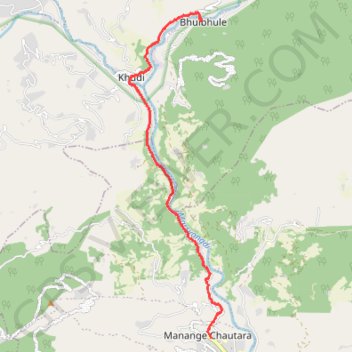
Tour Annapurna - Jour 01 - Besisahar - Bhulbhule
Randonnée entre Besisahar et Bhulbhule. #Randonnée
- Distance: 8.4 Km
- Elevation gain: 315 m
- Maximum elevation: 837 m
- Elevation loss: 295 m
- Minimum elevation: 740 m
- Moving time: 2 h 8 m
- Moving speed: 3.9 Km/h
- Maximum speed: 6.4 Km/h
- Total time: 2 h 34 m
- Global speed: 3.3 Km/h
- Date: 2014-03-31
Interactive map
GPS track profile
About this GPS track
Name: Tour Annapurna - Jour 01 - Besisahar - Bhulbhule GPS track, route, trail
Coordinates: 28.23652 84.35732 28.29183 84.37514
Other GPS tracks
Click on a GPS track to view route, its statistics and profile.
Besisahar à Bulbhule
Népal > Gandaki > लमजुङ > Manange Chautara
Randonnée entre Besisahar et Bhulbhule. #Randonnée
Distance: 12.3 Km • Elevation gain: 425 m • Maximum elevation: 848 m