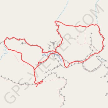
Peek-a-Boo Slot Canyon, Spooky Slot Canyon and Dry Fork Narrows Loop
Loop hike via Lower Dry Fork Trail, Peek-a-Boo Slot Canyon, Spooky Slot Canyon, Dry Fork Coyote Gulch Trail and Dry Fork Narrows Trail in the Scorpion Wilderness Study Area and the Grand Staircase-Escalante National Monument. #Hike #Loop #Canyon #Nature #Wilderness
- Distance: 5.9 Km
- Elevation gain: 167 m
- Maximum elevation: 1,512 m
- Elevation loss: 167 m
- Minimum elevation: 1,423 m
- Moving time: 35 m 29 s
- Moving speed: 10.0 Km/h
- Maximum speed: 11.8 Km/h
- Total time: 35 m 29 s
- Global speed: 10.0 Km/h
- Date: 2009-12-31
Interactive map
GPS track profile
About this GPS track
Name: Peek-a-Boo Slot Canyon, Spooky Slot Canyon and Dry Fork Narrows Loop GPS track, route, trail
Start: Lower Dry Fork Trail, Utah, United States (37.47677 -111.22008)
End: Lower Dry Fork Trail, Utah, United States (37.47677 -111.22006)
Coordinates: 37.47677 -111.22555 37.48576 -111.20837
Other GPS tracks
Click on a GPS track to view route, its statistics and profile.