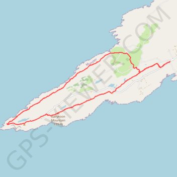
Ballyroon Mountain - Sheep's Head
Interactive map
GPS track profile
About this GPS track
Name: Ballyroon Mountain - Sheep's Head GPS track, route, trail
Start: Sheepshead, West Cork, County Cork, Munster, Ireland (51.56386 -9.75860)
End: Sheepshead, West Cork, County Cork, Munster, Ireland (51.56390 -9.75845)
Coordinates: 51.54250 -9.84770 51.56698 -9.75845
Other GPS tracks
Click on a GPS track to view route, its statistics and profile.
RT5-1 Rosslare - Kinsale
Distance: 2,860.3 Km • Elevation gain: 27,381 m • Maximum elevation: 420 m
Trace IRELAND
Distance: 1,506.7 Km • Elevation gain: 13,359 m • Maximum elevation: 524 m
RT5-1 Rosslare - Kinsale
Distance: 3,867.1 Km • Elevation gain: 36,115 m • Maximum elevation: 524 m
RT5-1 Rosslare - Kinsale
Distance: 1,353.5 Km • Elevation gain: 15,245 m • Maximum elevation: 420 m
39: Dunmanus – Ballydehob (Developed with signs)
Distance: 48.6 Km • Elevation gain: 704 m • Maximum elevation: 158 m