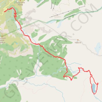
Lake Anne Loop
Loop hike to the Lake Ann from Austin Pass via Lake Ann Trail in the Mount Baker Wilderness. #Hike #Loop #Lake #Mountain #Nature #Forest #Wilderness
- Distance: 13.6 Km
- Elevation gain: 759 m
- Maximum elevation: 1,485 m
- Elevation loss: 754 m
- Minimum elevation: 1,199 m
- Moving time: 5 h 37 m
- Moving speed: 2.4 Km/h
- Maximum speed: 7.1 Km/h
- Total time: 6 h 33 m
- Global speed: 2.1 Km/h
- Date: 2018-10-10
Interactive map
GPS track profile
About this GPS track
Name: Lake Anne Loop GPS track, route, trail
Start: Lake Ann Trail, Whatcom County, Washington, United States (48.84991 -121.68560)
End: Lake Ann Trail, Whatcom County, Washington, United States (48.84997 -121.68611)
Coordinates: 48.82495 -121.68611 48.85124 -121.64255
Other GPS tracks
Click on a GPS track to view route, its statistics and profile.
Chain Lakes and Wild Goose Trails Loop
United States > Washington > Whatcom County
Loop hike via Bagley Dam, Chain Lakes Trail, Bagley Lakes, Iceberg Lake, Mazama Lake, Wild Goose Trail, Terminal Lake and Heather Meadows in the Mount Baker Wilderness. #Hike #Loop #Lake #Nature #Mountain #River #Forest #Wilderness
Distance: 12.5 Km • Elevation gain: 623 m • Maximum elevation: 1,666 m
Northern part of the Pacific Crest Trail (PCT)
United States > Oregon > Klamath County
Hike on the Pacific Crest National Scenic Trail from Crater Lake to Canada Border through Oregon and Washington along the Sierra Nevada and Cascade mountain ranges. #Hike #Mountain #SierraNevada #Cascade #Nature #Forest #Park #PCT
Distance: 1,198.3 Km • Elevation gain: 44,308 m • Maximum elevation: 2,307 m