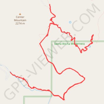
Reynolds Creek, Center Mountain, Lucky Strike Trails
Sierra Ancha Wilderness
- Distance: 20.2 Km
- Elevation gain: 1,133 m
- Maximum elevation: 2,290 m
- Elevation loss: 1,133 m
- Minimum elevation: 1,803 m
- Moving time: 4 h 53 m
- Moving speed: 4.1 Km/h
- Maximum speed: 7.0 Km/h
- Total time: 5 h 41 m
- Global speed: 3.6 Km/h
- Date: 2023-12-30
Interactive map
GPS track profile
About this GPS track
Name: Reynolds Creek, Center Mountain, Lucky Strike Trails GPS track, route, trail
Start: Reynolds Trail #150, Gila County, Arizona, United States (33.84754 -110.92628)
End: Reynolds Trail #150, Gila County, Arizona, United States (33.84746 -110.92621)
Coordinates: 33.84013 -110.92628 33.86543 -110.89988
Other GPS tracks
Click on a GPS track to view route, its statistics and profile.
Reynolds, Murphy, Rim, Moody Point Trails
United States > Arizona > Gila County
Sierra Ancha Wilderness
Distance: 22.5 Km • Elevation gain: 1,068 m • Maximum elevation: 2,359 m