Profitis Ilias de Santorin
- Distance: 7.7 Km
- Elevation gain: 533 m
- Maximum elevation: 550 m
- Elevation loss: 608 m
- Minimum elevation: -1 m
Interactive map
GPS track profile
About this GPS track
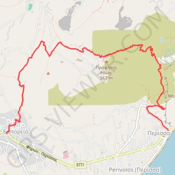
Name: Profitis Ilias de Santorin GPS track, route, trail
Coordinates: 36.35681 25.44433 36.37114 25.47574
Other GPS tracks
Click on a GPS track to view route, its statistics and profile.
Profitis Ilias de Santorin
Grèce > Égée > Περιφερειακή Ενότητα Θήρας > Δημοτική Ενότητα Θήρας > Emborío
Randonnée entre Emporio et Perissa. #Randonnée
Distance: 8.0 Km • Elevation gain: 571 m • Maximum elevation: 551 m