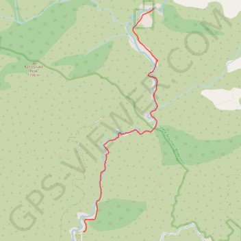
Return from Bridge to Nowhere
- Distance: 7.8 Km
- Elevation gain: 222 m
- Maximum elevation: 875 m
- Elevation loss: 469 m
- Minimum elevation: 611 m
- Moving time: 1 h 53 m
- Moving speed: 4.1 Km/h
- Maximum speed: 9.9 Km/h
- Total time: 2 h 19 m
- Global speed: 3.3 Km/h
- Date: 2009-05-31
Interactive map
GPS track profile
About this GPS track
Name: Return from Bridge to Nowhere GPS track, route, trail
Start: East Fork Trail, Los Angeles County, California, United States (34.28286 -117.74722)
End: East Fork Road, Los Angeles County, California, United States (34.23718 -117.76472)
Coordinates: 34.23718 -117.76472 34.28293 -117.74620
Other GPS tracks
Click on a GPS track to view route, its statistics and profile.
Bridge to Nowhere
United States > California > Los Angeles County
Distance: 15.4 Km • Elevation gain: 563 m • Maximum elevation: 864 m