Bridge to Nowhere
Hike to Bridge to Nowhere via East Fork Trail along the East Fork San Gabriel River in the Angeles National Forest and the Sheep Mountain Wilderness. #Hike #River #Nature #Mountain #Forest #Angeles
- Distance: 7.8 Km
- Elevation gain: 421 m
- Maximum elevation: 864 m
- Elevation loss: 183 m
- Minimum elevation: 611 m
Interactive map
GPS track profile
About this GPS track
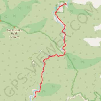
Name: Bridge to Nowhere GPS track, route, trail
Start: East Fork Road, Los Angeles County, California, United States (34.23713 -117.76481)
End: East Fork Trail, Los Angeles County, California, United States (34.28278 -117.74583)
Coordinates: 34.23713 -117.76481 34.28339 -117.74583
Other GPS tracks
Click on a GPS track to view route, its statistics and profile.
Return from Bridge to Nowhere
United States > California > Los Angeles County
Distance: 7.8 Km • Elevation gain: 222 m • Maximum elevation: 875 m
Bridge to Nowhere
United States > California > Los Angeles County
Distance: 15.4 Km • Elevation gain: 563 m • Maximum elevation: 864 m