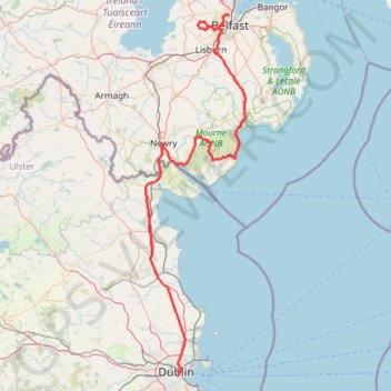
TT22 J4 J2/06 : Dublin à Belfast
- Distance: 250.3 Km
- Elevation gain: 2,609 m
- Maximum elevation: 390 m
- Elevation loss: 2,566 m
- Minimum elevation: 0 m
Interactive map
GPS track profile
About this GPS track
Name: TT22 J4 J2/06 : Dublin à Belfast GPS track, route, trail
Coordinates: 53.33166 -6.44569 54.63485 -5.83396
Other GPS tracks
Click on a GPS track to view route, its statistics and profile.
Howth Bog of Frogs Loop
Irlande > County Dublin > Howth
Distance: 12.0 Km • Elevation gain: 424 m • Maximum elevation: 124 m
Belfast to Dungannon
United Kingdom > Northern Ireland > County Antrim > Belfast
Bicycle ride from Belfast Big Fish to Dungannon.
Distance: 83.3 Km • Elevation gain: 549 m • Maximum elevation: 75 m
Trace IRELAND
Distance: 1,506.7 Km • Elevation gain: 13,359 m • Maximum elevation: 524 m
RT5-1 Rosslare - Kinsale
Distance: 2,860.3 Km • Elevation gain: 27,381 m • Maximum elevation: 420 m
CTS-N.Irelandv1.1-Belfast-Titanic>Enniscrone-via antrim coast-209miles
United Kingdom > Northern Ireland > County Down > Belfast
Distance: 335.8 Km • Elevation gain: 3,985 m • Maximum elevation: 271 m
RT5-1 Rosslare - Kinsale
Distance: 3,867.1 Km • Elevation gain: 36,115 m • Maximum elevation: 524 m
Howth Bog of Frogs Loop
Ireland > County Dublin > Howth
Distance: 12.0 Km • Elevation gain: 428 m • Maximum elevation: 124 m
Lagan & Lough
United Kingdom > Northern Ireland > County Antrim > Tullynacross
Distance: 29.4 Km • Elevation gain: 153 m • Maximum elevation: 35 m
TT22 J3 M1/06 : Port de Cork à Dublin
Distance: 358.2 Km • Elevation gain: 4,279 m • Maximum elevation: 524 m
TT22 J5 V3/06 : Belfast à Belfast
Royaume-Uni > Irlande du Nord > County Antrim > Belfast
Distance: 252.4 Km • Elevation gain: 2,552 m • Maximum elevation: 264 m
Newry Canal Towpath
United Kingdom > Northern Ireland > County Armagh > Portadown
Distance: 32.3 Km • Elevation gain: 95 m • Maximum elevation: 29 m
Royal canal way
Ireland > County Meath > Enfield
#Bike
Distance: 43.7 Km • Elevation gain: 98 m • Maximum elevation: 81 m