Howth Bog of Frogs Loop
- Distance: 12.0 Km
- Elevation gain: 424 m
- Maximum elevation: 124 m
- Elevation loss: 424 m
- Minimum elevation: -1 m
- Moving time: 3 h 5 m
- Moving speed: 3.9 Km/h
- Maximum speed: 8.3 Km/h
- Total time: 3 h 39 m
- Global speed: 3.3 Km/h
- Date: 2018-05-13
Interactive map
GPS track profile
About this GPS track
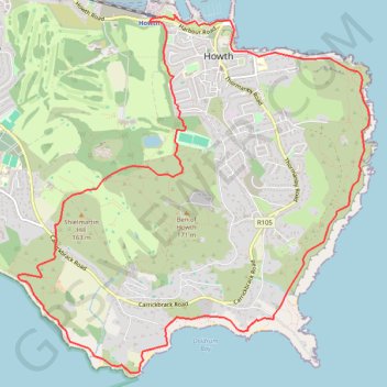
Name: Howth Bog of Frogs Loop GPS track, route, trail
Coordinates: 53.36068 -6.09189 53.38914 -6.04501
Other GPS tracks
Click on a GPS track to view route, its statistics and profile.
TT22 J4 J2/06 : Dublin à Belfast
Irlande > County Dublin > Dublin
Distance: 250.3 Km • Elevation gain: 2,609 m • Maximum elevation: 390 m
RT5-1 Rosslare - Kinsale
Distance: 3,867.1 Km • Elevation gain: 36,115 m • Maximum elevation: 524 m
Howth Bog of Frogs Loop
Ireland > County Dublin > Howth
Distance: 12.0 Km • Elevation gain: 428 m • Maximum elevation: 124 m