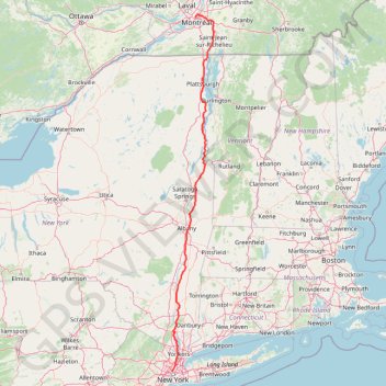
Montréal - New York
- Distance: 637.3 Km
- Elevation gain: 4,134 m
- Maximum elevation: 301 m
- Elevation loss: 4,201 m
- Minimum elevation: -2 m
Interactive map
GPS track profile
About this GPS track
Name: Montréal - New York GPS track, route, trail
Coordinates: 40.74476 -74.00863 45.52562 -73.24881
Other GPS tracks
Click on a GPS track to view route, its statistics and profile.
Rockleigh Woods Sanctuary
United States > New Jersey > Bergen County > Rockleigh
Distance: 11.0 Km • Elevation gain: 325 m • Maximum elevation: 150 m
Corinth Reservoir
United States > New York > Saratoga County > Town of Corinth
Distance: 7.0 Km • Elevation gain: 206 m • Maximum elevation: 398 m
Palisades Interstate Park Mountain Bike Ride
United States > New Jersey > Bergen County > Rockleigh
Distance: 13.7 Km • Elevation gain: 330 m • Maximum elevation: 162 m
Alpine & Rockleigh
United States > New Jersey > Bergen County > Alpine
Palisades Interstate Park.
Distance: 15.0 Km • Elevation gain: 309 m • Maximum elevation: 171 m
Tiffany Preserve, Oyster Bay, NY
United States > New York > Nassau County > Village of Oyster Bay Cove
Distance: 15.5 Km • Elevation gain: 165 m • Maximum elevation: 66 m
Allen Mountain
United States > New York > Essex County > Town of Newcomb
Hike / snowshoes from East River Parking to Allen Mountain via East River Trail, Hudson River, Lake Jimmy, Lake Sally, Allen Mountain Trail and Allen Lookout North in the High Peaks Wilderness and the Adirondack Park. #Hike #Snowshoes #Mountain #Nature #Forest #Lake #River #Park #Wilderness #Adirondack
Distance: 28.7 Km • Elevation gain: 1,060 m • Maximum elevation: 1,302 m
100 acre woods
United States > New York > Saratoga County > Town of Malta
Distance: 8.8 Km • Elevation gain: 123 m • Maximum elevation: 109 m
Palisades Interstate Park Loop
United States > New Jersey > Bergen County > Alpine
Loop hike along the Hudson River via Long Path, Shore Trail, Peanut Leap Cascade, Giant Stairs, Blue and white Trail, State Line Lookout and Border Monument in the Palisades Interstate Park. #Hike #Loop #River #Nature #Forest #Park #Falls #Overlook
Distance: 7.5 Km • Elevation gain: 391 m • Maximum elevation: 164 m
Saddleback Mountain
United States > New York > Essex County > Town of Keene
Hike from Garden Parking Area to Saddleback Mountain via Phelps Trail, Orebed Brook Trail and State Range Trail in the Johns Brook Primitive Area, the High Peaks Wilderness and the Adirondack Park. #Hike #Mountain #Nature #Forest #River #Park #Wilderness
Distance: 24.5 Km • Elevation gain: 1,085 m • Maximum elevation: 1,361 m
Mount Marcy, Mount Skylight and Gray Peak
United States > New York > Essex County > Town of Keene > Town of Newcomb
Return hike from Mount Marcy to Heart Lake via Mount Marcy Trail, Schofield Cobble, Four Corners, Skylight Trail, Lake Tear of the Clouds, Gray Peak Trail, Van Hoevenberg Trail, Indian Falls and Marcy Dam Pond in the High Peaks Wilderness and the Adirondack Park. #Hike #Mountain #Nature #Forest #Lake #Falls #Park #Wilderness
Distance: 17.9 Km • Elevation gain: 607 m • Maximum elevation: 1,612 m
Mount Colden Loop
United States > New York > Essex County
Loop hike from Heart Lake to Mount Colden via Van Hoevenberg Trail, Marcy Dam Pond, Avalanche Pass Trail, Avalanche Pass, Avalanche Lake, Lake Colden, Mount Colden Trail, L. Morgan Porter Trail, Lake Arnold and Lake Arnold Trail in the High Peaks Wilderness and the Adirondack Park. #Hike #Loop #Mountain #Lake #Forest #Nature #Park…
Distance: 21.7 Km • Elevation gain: 1,000 m • Maximum elevation: 1,415 m
Mount Skylight
United States > New York > Essex County
Hike to Mount Skylight via Adirondack Loj Road, Heart Lake, Van Hoevenberg Trail, Marcy Dam, Avalanche Pass Trail, Avalanche Camp, Lake Arnold Trail, Lake Arnold, Mount Marcy Trail, Lake Tear of the Clouds, Four Corners and Skylight Trail in the High Peaks Wilderness and the Adirondack Park. #Hike #Mountain #Nature #Forest #Lake…
Distance: 33.0 Km • Elevation gain: 1,295 m • Maximum elevation: 1,492 m
Montréal - Lanoraie
Canada > Quebec > Urban agglomeration of Montreal > Montreal
Saint Lawrence River. #Bike #Montréal #Lanoraie #SaintLawrence
Distance: 70.1 Km • Elevation gain: 181 m • Maximum elevation: 52 m
Salaberry-de-Valleyfield - Montréal
Canada > Quebec > Beauharnois-Salaberry > Salaberry-de-Valleyfield
#Bike
Distance: 89.9 Km • Elevation gain: 363 m • Maximum elevation: 70 m
Mount Marcy, Table Top and Phelps Mountain
United States > New York > Essex County
Hike from Heart Lake to Mount Marcy, Table Top and Phelps Mountain via Van Hoevenberg Trail, Marcy Dam, Phelps Mountain Trail, Indian Falls and Tabletop Mountain Trail in the High Peaks Wilderness and the Adirondacks Park. #Hike #Mountain #Nature #Forest #Lake #Falls #River #Wilderness #Park
Distance: 29.5 Km • Elevation gain: 1,679 m • Maximum elevation: 1,612 m
Giant Mountain and Rocky Peak Ridge
United States > New York > Essex County > Town of Keene
Hike from Chapel Pond to Giant Mountain and Rocky Peak Ridge via Ridge Trail, Ridge Lookout, Giant Washbowl, Roaring Brook Trail, East Trail and Giant East Slide Lookout in the Giant Mountain Wilderness and Adirondack Park. #Hike #Mountain #Nature #Forest #Lake #Park #Wilderness
Distance: 13.1 Km • Elevation gain: 1,336 m • Maximum elevation: 1,387 m
Montréal - Vaudreuil-Dorion
Canada > Québec > Vaudreuil-Soulanges > Vaudreuil-Dorion
#Vélo
Distance: 46.9 Km • Elevation gain: 98 m • Maximum elevation: 93 m
Dix Mountain Loop
United States > New York > Essex County > Town of Keene
Loop hike on the Dix Range via Boquet Forks Trail, Shoebox Falls, Lillypad Pond, Grace Peak, Grace Peak Trail, South Dix Lookout, South Dix, Dix Range Trail, Macomb Mountain, Hough Peak, Beckhorn Trail, Dix Mountain, Dix Trail and Round Pond in the High Peaks Wilderness and the Adirondack Park. #Hike #Loop #Mountain #Lake #River…
Distance: 27.1 Km • Elevation gain: 1,577 m • Maximum elevation: 1,456 m
Mount Redfield and Cliff Mountain
United States > New York > Essex County
Hike from Heart Lake to Mount Redfield and Cliff Mountain via Van Hoevenberg Trail, Marcy Dam, Avalanche Pass Trail, Avalanche Camp, Lake Arnold Trail, Lake Arnold, Mount Marcy Trail, Mount Redfield Trail and Cliff Mountain Trail in the High Peaks Wilderness and Adirondack Park. #Hike #Mountain #Nature #Forest #Lake #River #Park…
Distance: 29.7 Km • Elevation gain: 1,399 m • Maximum elevation: 1,388 m
Big Slide Mountain Loop
United States > New York > Essex County > Town of Keene
Lop hike from Garden Parking to Big Slide Mountain via Phelps Trail, Big Slide Trail, The Brothers Trail, Third Brother, Second Brother and First Brother in the High Peaks Wilderness. #Hike #Loop #Mountain #Nature #Wilderness
Distance: 14.5 Km • Elevation gain: 855 m • Maximum elevation: 1,252 m
Hurricane Mountain
United States > New York > Essex County > Town of Keene > Town of Elizabethtown
Hike to the Hurricane Mountain in the Hurricane Mountain Wilderness. #Hike #Mountain #Nature #Forest #Wilderness
Distance: 5.1 Km • Elevation gain: 588 m • Maximum elevation: 1,103 m
Morning Run
United States > New York > New York County > New York
Distance: 13.7 Km • Elevation gain: 158 m • Maximum elevation: 34 m
Traversée New York
États-Unis d'Amérique > New York > New York
Vélo. En aller simple. #Vélo
Distance: 43.1 Km • Elevation gain: 378 m • Maximum elevation: 43 m
Niagara - Albany
États-Unis d'Amérique > New York > Niagara County > City of Niagara Falls
Distance: 538.0 Km • Elevation gain: 2,411 m • Maximum elevation: 198 m
East Hawkesbury - Montréal
Canada > Ontario > Prescott and Russell Counties > East Hawkesbury
#Bike #EastHawkesbury #Montréal
Distance: 91.4 Km • Elevation gain: 393 m • Maximum elevation: 91 m
Pierreville - Leclercville
Canada > Quebec > Urban agglomeration of Montreal > Montreal
#Bike #Pierreville #Leclercville #Atlantic
Distance: 120.8 Km • Elevation gain: 324 m • Maximum elevation: 36 m