Import a GPX file

JMT1-16847633

  • Distance: 401.4 Km
  • Elevation gain: 15,190 m
  • Maximum elevation: 4,385 m
  • Elevation loss: 17,043 m
  • Minimum elevation: 1,221 m

Interactive map

GPS track profile

About this GPS track
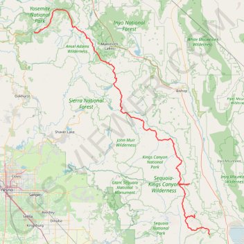
Other GPS tracks

Click on a GPS track to view route, its statistics and profile.

Vernal and Nevada Falls Loop

United States > California > Mariposa County > Curry Village

Yosemite National Park. Merced River. #Hike #Loop #Waterfall #River #Mountain #Forest #Lake #Nature #Yosemite

Distance: 11.8 Km • Elevation gain: 910 m • Maximum elevation: 1,846 m

Tenaya Creek and Mirror Lake

United States > California > Mariposa County > Curry Village

Loop hike along Tenaya Creek via Mirror Lake on Valley Loop Trail in the Yosemite National Park. #Hike #Loop #Nature #River #Forest #Lake #Mountain #Park #Yosemite

Distance: 7.2 Km • Elevation gain: 160 m • Maximum elevation: 1,277 m

Vernal Falls

United States > California > Mariposa County > Curry Village

Yosemite National Park. Merced River. #Hike #Waterfall #River #Mountain #Forest #Nature

Distance: 5.8 Km • Elevation gain: 480 m • Maximum elevation: 1,584 m

Vernal Fall and Clark Point Loop

United States > California > Mariposa County > Curry Village

Loop hike to Vernal Fall and Clark Point via Happy Isles Bridge, Merced River, John Muir Trail and Mist Trail in the Yosemite National Park. #Hike #Loop #Nature #Falls #River #Forest #Mountain #Yosemite #Park

Distance: 9.4 Km • Elevation gain: 806 m • Maximum elevation: 1,699 m

Half Dome

United States > California > Mariposa County > Curry Village

Hike from Happy Isles to Half Dome via John Muir Trail, Merced River, Vernal Fall and Mist Trail in the Yosemite National Park. #Hike #Mountain #Nature #Forest #River #Fall #Yosemite #Park

Distance: 24.8 Km • Elevation gain: 1,983 m • Maximum elevation: 2,687 m

Clouds Rest from Tenaya Lake

United States > California > Mariposa County

#Hike #Yosemite

Distance: 18.8 Km • Elevation gain: 872 m • Maximum elevation: 2,990 m

Clouds Rest from Tenaya Lake

United States > California > Mariposa County

Yosemite National Park. #Hike #Mountain #Lake #Forest #Nature #Yosemite

Distance: 19.3 Km • Elevation gain: 881 m • Maximum elevation: 2,991 m

Mount Whitney

United States > California > Inyo County

Hike to Mount Whitney via Mount Whitney Trail, Lone Pine Lake, Mirror Lake, Consultation Lake, Trail Crest and John Muir Trail in John Muir Wilderness. #Hike #Mountain #Nature #Wilderness #Muir #Forest #Lake

Distance: 16.9 Km • Elevation gain: 2,175 m • Maximum elevation: 4,415 m

Yosemite North Dome Loop

United States > California > Mariposa County > Curry Village

Loop hike to North Dome via Lower Mirror Lake, Tenaya Creek, Valley Loop Trail, Snow Creek Trail, North Dome Trail, Upper Yosemite Fall Trail, Oh My Gosh Point and Columbia Rock in the Yosemite National Park. #Hike #Loop #Mountain #Nature #Lake #Forest #Fall #Park #Yosemite

Distance: 32.0 Km • Elevation gain: 2,275 m • Maximum elevation: 2,484 m

Nevada Fall Loop

United States > California > Mariposa County > Curry Village

Loop hike from Curry Village to Nevada Fall via Happy Isles Bridge, Merced River, John Muir Trail, Mist Trail, Vernal Fall and Clark Point in the Yosemite National Park. #Hike #Loop #Mountain #River #Falls #Nature #Forest #Park #Yosemite

Distance: 14.3 Km • Elevation gain: 1,153 m • Maximum elevation: 1,849 m

John Muir Trail and Merced River Falls Loop

United States > California > Mariposa County > Curry Village

Loop hike via John Muir Trail, Nevada Fall, Merced River, Little Yosemite Valley, Mist Trail, Silver Apron and Vernal Fall in the Yosemite National Park. #Hike #Loop #Yosemite #Park #Nature #River #Mountain #Falls #Forest

Distance: 15.4 Km • Elevation gain: 1,154 m • Maximum elevation: 1,894 m

Vernal Fall and Nevada Fall

United States > California > Mariposa County > Curry Village

Hike from Happy Isles to Vernal Fall and Nevada Fall along the Merced River on the Mist Trail in the Yosemite National Park. #Hike #Falls #River #Nature #Forest #Mountain #Yosemite

Distance: 4.7 Km • Elevation gain: 679 m • Maximum elevation: 1,831 m

Half Dome via Vernal and Nevada Falls

United States > California > Mariposa County > Curry Village

Yosemite National Park. Merced River. #Hike #Mountain #Waterfall #River #Forest #Nature

Distance: 26.7 Km • Elevation gain: 2,054 m • Maximum elevation: 2,693 m

Mammoth Lakes Loop

United States > California > Mono County > Mammoth Lakes > Lake Mary

Loop hike via Lake Mary, Lake Barret, T J Lake, Lake George, Lake Mamie and Mammoth Creek in the Inyo National Forest. #Hike #Loop #Lake #Forest #Nature #River #Mountain

Distance: 5.4 Km • Elevation gain: 159 m • Maximum elevation: 2,842 m

Big Pine Lakes Loop

United States > California > Inyo County

John Muir Wilderness. Inyo National Forets. #Hike #Loop #Lake #Mountain #River #Forest #Nature

Distance: 24.5 Km • Elevation gain: 1,235 m • Maximum elevation: 3,432 m

Mammoth to Bridgeport

United States > California > Mono County > Mammoth Lakes

Northern California Backcountry Discovery Route (CABDR-North)

Distance: 152.5 Km • Elevation gain: 2,191 m • Maximum elevation: 2,822 m

Moro Rock

United States > California > Tulare County

Sequoia National Park. #Hike #Forest #Mountain #Nature

Distance: 0.7 Km • Elevation gain: 90 m • Maximum elevation: 2,037 m

Lone Pine Lake

United States > California > Inyo County

Hike to Lone Pine Lake via Mount Whitney Trail in John Muir Wilderness. #Hike #Mountain #Lake #Nature #Forest #Wilderness

Distance: 4.7 Km • Elevation gain: 549 m • Maximum elevation: 3,067 m

Grant Grove Village to Sequoia Lake Loop

United States > California > Tulare County > Grant Grove Village

Loop hike from Grant Grove Village to Sequoia Lake via Sunset Trail, Ella Falls, Dead Giant Loop Trail, Sequoia Lake Overlook, North Grove Trail, Centennial Stump, General Grant Tree, Tennessee Tree, Michigan Tree and South Boundary Trail in the Kings Canyon National Park and the Giant Sequoia National Forest. #Hike #Loop #Nature

Distance: 17.5 Km • Elevation gain: 643 m • Maximum elevation: 2,023 m

Tokopah Falls

United States > California > Tulare County

Tokopah Valley. Sequoia National Park. #Hike #Mountain #River #Waterfall #Forest #Nature

Distance: 6.5 Km • Elevation gain: 208 m • Maximum elevation: 2,250 m

Vernal and Nevada Falls Loop

United States > California > Mariposa County > Curry Village

Distance: 11.8 Km • Elevation gain: 910 m • Maximum elevation: 1,846 m

Mount Whitney

United States > California > Inyo County

John Muir Wilderness. Lone Pine Creek. #Hike #Mountain #Lake #River #Forest #Nature

Distance: 33.3 Km • Elevation gain: 2,483 m • Maximum elevation: 4,415 m

Walker - Auberry

États-Unis d'Amérique > Californie > Mono County > Walker

Vélo. En aller simple entre Walker et Auberry. #Vélo

Distance: 354.0 Km • Elevation gain: 6,633 m • Maximum elevation: 3,039 m